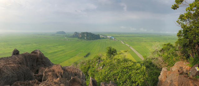
Bukit Tok Dun located in Perlis, or to be more precise, it is actually at the border of Perlis and Kedah. If you are looking for some easy trail to chill yourself while enjoying the surrounding view, here is a good choice for you. Get going to see more about this mini Cameron Highlands located in northern area of Malaysia.
 |
| How Leisure to Spend Your Weekends Here |
 |
| My hiking partners of the day |
Height : 325 meter
Location : Water Tower Bukit Tok Dun
Difficulty Level : 3/10
How to Get There?
You can search "
Water Tower Bukit Tok Dun" in Waze and you will reach your destination easily.
Once you reach the destination, along the road is the place to park your car. Just follow where the majority park.
Not really dangerous, just make sure to bring your belongings with you and lock your car properly.
So we start our journey from here : An open space of road
We couldn't recognize the way, as they all look pretty much the same, so we just follow the crowd.
 |
| Start of Your Journey : An Open Space of Road |
And after that, you will see these palm oil (Kelapa sawit) plantation area, here is where you should enter. Follow this path and u will see the entrance very soon.


After a few distance...
Use this small wooden bridge as your guidance. If you see this, you are at the right path!
And here start the trail. You can use the white sign board as a guide when you return.
Because here is where we started to get lost on the way back (More stories ahead..)
What is so special with it?
Bukit Tok Dun is very well known among hikers for the pretty sunrise view, as you can enjoy sea of clouds just right in front of you. Also, it is not difficult to hike, because the hill is half-developed for some plantation so the trails are very clear and straight-forward.
 |
| Amazing sunrise view on the way uphill |
 |
| You can see an extensive chain of mountains from distance |
 |
| Nature never failed to amaze us |
 |
| So called as MINI CAMERON. |
We went there on 7 o'clock in the morning, which is kinda late but we were lucky enough to get to see the sunrise and sea of clouds.
The whole journey up to the peak only takes around 20-40 minutes depends your personal fitness, with some trek of steepness of around 30-40 degree.
And from the top of Bukit Tok Dun, you can get to see a panoramic view of the surrounding landscape. There are pretty much of ideal places for photos such as the flag, the wooden house etc.
 |
| A picture with Malaysia National Flag |
 |
| The peak of BUKIT TOK DUN |
Is it dangerous?
Since it is so easy to hike, why is it dangerous?
If you google search "Bukit Tok Dun", you can see that there are quite a lots of news about people getting lost (cemas sesat) and calling help from bomba.
And the same thing happened to us!
Because the landscape comprehends high and low mountain ranges, rolling country and plain, so it is quite easy to get confused and you might ended up walking to another hill. We accidentally walked to the other side on our way back, but just within minutes, we sensed that something was wrong, so we headed back.
We thought that we were safe but was proven wrong. At downhill where we were almost back to the initial palm oil plantation, we turned to the wrong side and started our "GET LOST IN THE JUNGLE" story. Because my friend came here before, and she claimed that she did passed through all the jungles (or to be more precise, a rubber tree plantations) last time being guided by a group of hikers, so we just continue going until we found that there were no end for the road & we had already spent about half an hour here.
So we opened our waze, tried to get the location of water tower and we blindly walked for about another half an hour but still get stuck inside. Trying to get help but there was no one around. Out of no way, we decided to walk back and finally thanks god! We found some one at the mid way hiking, we shouted to each others (thanks god again they heard us) and they gave us the correct direction to find our way out.
So we were supposed to get downhill by 9am but ended up reaching by 11am.
2 HOURS getting lost in the rubber tree plantations. What an unforgettable experience!
 |
Here was the place where we started to get lost!
(Noted that this is the same white sign board at the starting point) |
 |
| All the trails look pretty much the same for us |
 |
| Most of them are open spaces like this so u might get confused easily |
 |
| You can recognize different sign boards along the way |
 |
| Finally we found the wooden bridge back! Thanks god. |
THE END
HAVE A NICE DAY!
AND HOPE YOU ENJOY READING.


Comments
Post a Comment